
Awantour.com. – Discussion about a map and location of Mount Bromo are important travel guides for any travelers to reach the mountain from various directions and explore.
Guide to Reach Bromo: the Map and Location of Mt. Bromo (2.329m asl)
Mount Bromo is one of the most recommended travel destinations in East Java. So it is easy to get the map and location of mt Bromo to guide you there. There are various ways to reach Bromo depending on from where you come. Once you arrive, you have huge area to explore. Knowing your way will help you navigating your trip to and in Bromo, even if you are with guide.
What Maps and Location of Bromo Show
If you plan to visit Bromo for quite some time, you need map to guide your way better to and around Bromo. Map and location of mount Bromo are available widely in various traveling websites, and they show you the entire area of Bromo and its surrounding, complete with popular destination spots, hiking trails, the entrance, and jeep route (the jeeps are only allowed to certain distance from Mount Bromo). Depending on the details of the map, you can also get information about what public transportation’s or rental vehicles you can use. Also, how much you should pay based on local currency.
A good map will also show you distances between Bromo and various important places. Those are from Bromo to Probolinggo Train Station and Tourism Information Center (50 kilometers), and Probolinggo Bus Station (45 kilometers). You can also get information about the nearest hotel, motel, and even camping ground. The most complete version of the map also shows you what important spots to know along the routes. Plus other useful information that you should know as traveler, whether you come alone or with guides.
Finally, the map and locations of mt Bromo also show places near and in the area of Bromo Tengger Semeru National Park, such as several villages (Gubuk Klakah, Jemplang, Cemoro Lawang, Ngadas, Tosari), all the view points, the tree famous lakes (Ranu Kumbolo, Ranu Pane, Ranu Regulo), Madakaripura Waterfall, and the Hindu temple that is a sacred place for Tengger people.
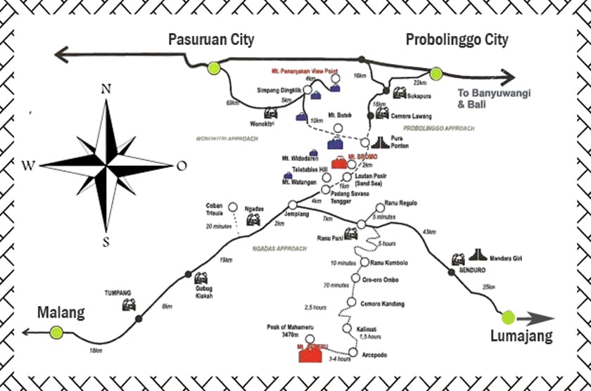
Important Routes and Places in Bromo Map and Location
Mt. Bromo is located in Probolinggo, East Java, Indonesia. So you have two options to access it if you are from outside East Java. If you come from Surabaya, which is the capital city of East Java Province, you can use bus from Surabaya (Bungurasih) Bus Station, before renting a car from local car rental in Probolinggo. If you come from Malang City, you can use the bus to go to Probolinggo. However, the route is slightly longer because you must go through Purbasari City before arriving in Probolinggo.
Once you arrive at Probolinggo Bus Station, you can use the nearest car rental to go to Bromo. This is because there are no public transportation that go to Bromo. Once you arrive at the entrance, you can rent a jeep to approach the mountain feet. However, you need to plan your trip carefully if you visit during peak season, because it can be hard to find hotel or jeep to rent.
- Read Also: Best Tourism at Bromo
Getting map and location of mount Bromo is important to know your way around, and even if you go with guide, you can get more benefits if you know your way around. But if you don’t mind, to make it easier to enjoy mount Bromo you can use Awan Tour agency is our service. So that your trip will be easier and more enjoyable.
